Aurora Forecast: What You Must Know
Understanding aurora forecasts changed the way I plan and experience aurora nights. Here is what's behind the numbers — and how to combine them with everything else that actually matters.
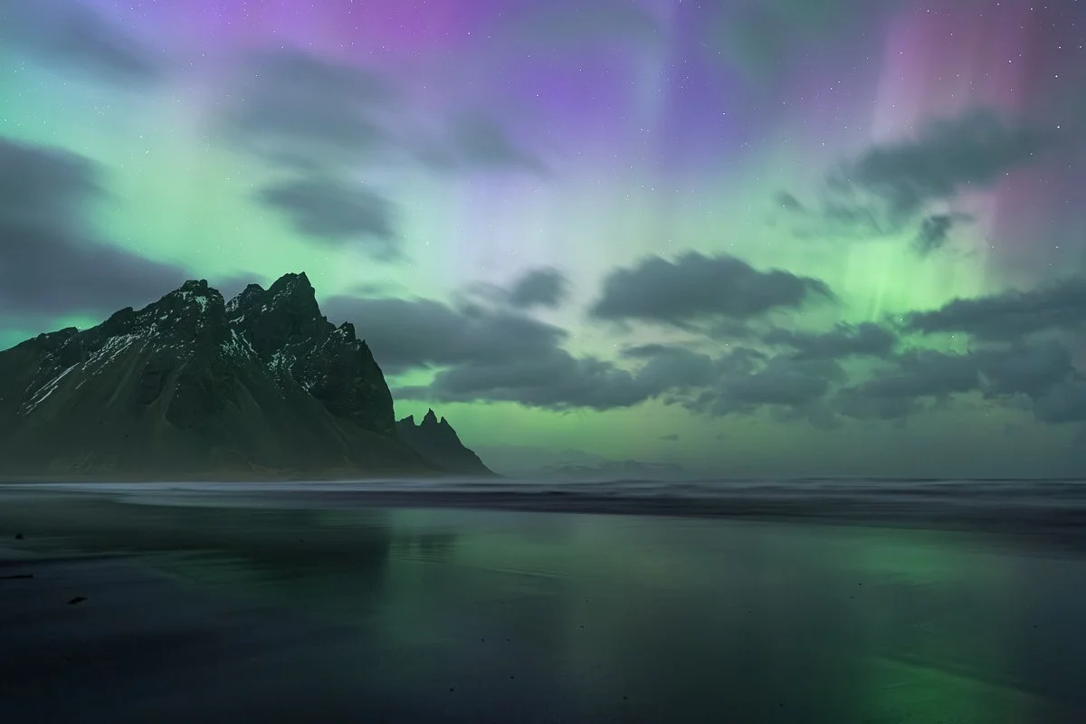
Stokksnes, Iceland. It got cloudy shortly and I moved to another spot.
Early on I made two mistakes that cost me good nights. The first was not putting cloud cover forecast first when deciding where to go. Once in Finland I nearly stayed put in bad weather while the aurora was dancing somewhere above the clouds. Instead I decided to drive 1.5 hours through severe conditions to a fell near Hetta in Lapland — just for the chance of a clear sky. I was lucky. That night turned out to be the best aurora show I had witnessed up to that point, and it changed my approach completely. Since then I always choose the clearest sky first, even if it means driving further. I plan possible locations in advance so I always have a good choice of spots depending on how the cloud cover forecast develops.
The second mistake was heading out based on the Kp forecast alone, before the solar wind data had confirmed it. I spent too many nights in the field watching and waiting for Bz to go negative. Over time I developed a workflow that avoids those frustrating moments.
The Kp forecast
If you've read the Kp Index and Northern Lights: Complete Guide, you already know what Kp is and what it means for aurora activity. Here's how to use the forecasts that publish it.
The 27-day forecast
The sun rotates roughly every 27 days. Active regions on its surface that produce geomagnetic activity tend to last several months, returning to face the Earth with each rotation. If there was elevated geomagnetic activity 27 days ago, there is a reasonable chance of similar activity these days. The 27-day forecast is built on exactly this logic and is published every Monday by the NOAA Space Weather Prediction Center.
It's worth keeping an eye on before a trip — not as a reliable prediction, but as a rough orientation of whether the period looks active or quiet. Treat it as approximate planning only — a predicted event may occur 1–2 days earlier or later than forecast, or may not occur at all.
The 3-day forecast
When the solar wind leaves the sun, it travels 150 million kilometres to Earth in about 3 days. The 3-day forecast is based on observations of current activity on the sun's surface and predicts the maximum expected Kp for each 3-hour interval over the coming three days — meaning Kp could reach the forecasted number at some point within those 3 hours.
This is the forecast to watch when you're already on a trip. It gives you a sense of what to expect over the coming nights — which look more active, which look quiet. Bear in mind that it is still impossible to predict the exact solar wind parameters when it leaves the sun and whether it will hit Earth effectively, so this forecast is an indication of what may happen, not a guarantee.
Solar wind parameters and the OVATION forecast
When the solar wind is about to reach Earth, it passes satellites positioned at the L1 Lagrange point — 1.5 million kilometres from Earth. These satellites, DSCOVR and ACE, measure the solar wind in real time and transmit the data back to NOAA. This gives us a short window of lead time before the solar wind reaches Earth's magnetosphere — the most accurate aurora prediction we have.
The parameters that matter
Here are the key parameters to watch and what values to look for.
Bz — the z-component of the solar wind magnetic field. This is the most critical parameter. When Bz is negative, the solar wind's magnetic field points opposite to Earth's, allowing solar wind energy to transfer more effectively into the magnetosphere and drive aurora activity. A sustained negative Bz of -2nT is a good sign; -5nT or -10nT is even better. The key word is sustained — a brief dip and recovery means less than a negative Bz that holds for an hour or two.
Solar wind speed. The second most important parameter. Typical solar wind speed is around 375 km/s. As it rises, more energy transfers over time, increasing aurora activity. Speed above 400 km/s is favorable; 600 km/s or 800 km/s is excellent. Speed also tells you how long it will take the measured solar wind to reach Earth — at 400 km/s, roughly one hour from the L1 satellites.
Magnetic field strength. The stronger the magnetic field, the more effectively energy transfers into the magnetosphere. Less influential than Bz and speed, but still worth noting.
Solar wind density. Not directly used by the OVATION model, but has an indirect effect through its influence on the magnetic field behavior.
The OVATION model
The OVATION Prime Model uses Bz, solar wind speed, and magnetic field strength to predict aurora activity and produce the aurora oval forecast you see on most apps and forecast tools. It's updated every 5 minutes and provides about an hour lead time depending on solar wind speed — the most reliable real-time aurora prediction available.
Do you need to watch all these solar wind parameters closely? Not necessarily. The OVATION model already incorporates them into its forecast, so watching the aurora oval probability is usually enough. But having some awareness of what the solar wind is actually doing — whether Bz is negative and holding, whether speed is elevated — helps you understand whether the real situation aligns with the Kp forecast for tonight.
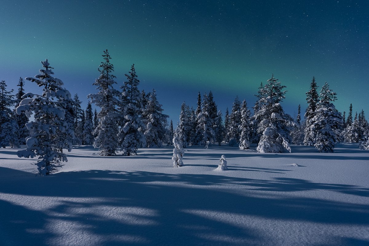
Finnish Lapland. The kind of night you enjoy and remember even without the lights.
Clouds
Clear sky is the single most important condition for seeing the northern lights. In the classic aurora regions — Lapland, Iceland, northern Norway, northern Canada — a clear sky almost guarantees you'll see at least some aurora that night. But if it's cloudy it doesn't matter how active the aurora is — you simply can't see it.
Clouds cause the most frustration in aurora photography. If the sky is clear you usually enjoy the night, waiting for the northern lights with anticipation and excitement — and you always find something worth photographing even without aurora. But if the aurora is dancing in the sky and you just can't see it, that's a different story and the most frustrating one. I know, I've been there.
That said, partial clouds can sometimes add to a composition — and that's the one consolation when the sky doesn't fully cooperate.
Wind and temperature
Even on a perfect night — clear sky, strong aurora — wind and temperature can end the session before the show even begins.
Cold weather is manageable if you're well prepared. Wind is less forgiving. It makes cold feel far colder, and in photography terms creates problems beyond comfort. Any moving element in the foreground — grass or branches — will blur in a long exposure. Strong wind makes stable shooting extremely difficult even with a tripod.
One night on Stokksnes in Iceland I had to set my tripod at the lowest possible position, press it to the ground with my weight, and wait for windows between the gusts. Even then, 90% of the shots from that night were blurred and unusable.
Calm conditions, on the other hand, create great opportunities. Still air means open water stays undisturbed and reflections become possible — something I always keep an eye on when checking the wind forecast.
Moon
Moon phase affects both aurora visibility and the look of the landscape. A bright full moon reduces the contrast of the aurora against the sky, making it harder to see at lower activity levels. At high aurora activity, moonlight makes less difference.
The other side of the trade-off is that moonlight illuminates the landscape beautifully. I always check when the moon rises and sets, and factor it into my location decisions when everything else looks equal.
How I actually use all of this
Before a trip I glance at the 27-day forecast to get a rough sense of whether the period looks active — which nights might be worth prioritising, when to be ready for a long night out. It's approximate and often wrong, but it's a useful starting point. I've found it's much better to adjust plans when needed than to start from scratch on the trip.
Once I'm on the trip, the first thing I check for any potential night is cloud cover and weather forecasts for several alternative spots within my reach. This is the most important check I do. In regions like Iceland and Norway the weather forecast changes constantly, so I keep a close eye on how it evolves throughout the day. Only when I have a sense of where the sky might be clear does aurora activity become the next filter.
In the evening I start checking solar wind parameters and the aurora oval — whether what's actually happening with the solar wind aligns with the Kp forecast for tonight. If the weather looks good, the Kp forecast is promising, and the solar wind supports it, I head straight to the planned spot. If the forecast is weak and the solar wind is completely calm, I usually wait. Aurora activity tends to peak around midnight, typically between 10pm and 2am — so there is usually enough time before the main window opens. If aurora probability starts rising, I get a notification.
When I'm on location I usually don't check forecasts — I can see the real conditions and focus on photography. But when deciding whether to wait, change spots, or head back, I always check solar wind activity, aurora probability, and the weather forecast for the coming hours.
One thing I always do: check the forecast for the next night and compare it to the current one. Patience is essential, but so is being rested. If tonight is fading and tomorrow looks more promising, it's better to stop and recover than push through an unproductive night.
Putting it all together
I use all these forecasts to choose the best possible place where I can go tonight and when is the best time to go there. It keeps me optimistic, motivated, and patient. Now, when I use my own app this process of planning becomes easy and enjoyable.
If you want all of these forecasts combined in one place, Step's Aurora Guide app was built exactly for that.